Indian Pincode Database
Welcome to one of India's largest and most extensive Pincode database. FindPincode.net has more than 150,000+ pin codes of different Indian states, cities, talukas. You can find comprehensive details about Postal offices from all the Indian states and union territories.
India has the largest Postal Network in the world with over 1, 54,882 Post Offices (as on 31.03.2014) of which 1, 39,182 (89.86%) are in the rural areas. At the time of independence, there were 23,344 Post Offices, which were primarily in urban areas. Thus, the network has registered a seven-fold growth since Independence, with the focus of this expansion primarily in rural areas. On an average, a Post Office serves an area of 21.22 Sq. Km and a population of 8221 people
What is PIN Code? (Postal Index Number)
A Postal Index Number or PIN or Pincode is a code in the post office numbering or post code system used by India Post, the Indian postal administration. The code is six digits long.
The PIN Code system was introduced on 15 August 1972. The system was introduced to simplify the manual sorting and delivery of mail by eliminating confusion over incorrect addresses, similar place names and different languages used by the public

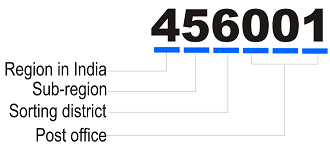
Let us check the above example Pin code. The pin code 456001 is of Ujjain, Madhya Pradesh. The first three digits of the PIN represent a specific geographical region called a sorting district that is headquartered at the main post office of the largest city and is known as the sorting office. So in this case its in Ujjain. A state may have one or more sorting districts depending on the volumes of mail handled.
The fourth digit represents the route on which a Delivery office is located in the sorting district. This is 0 for offices in the core area of the sorting district.
The last two digits represent the delivery office within the sorting district starting from 01 which would be the General Post Office or Head Office. The numbering of the delivery office is done chronologically with higher numbers assigned to newer delivery offices. If the volume of mails handled at a delivery office is too large, a new delivery office is created and the next available PIN is assigned. Thus two delivery offices situated next to each other will only have the first four digits in common
The first digit of PIN indicates as below:
| First Digit | Region | States Covered |
|---|---|---|
| 1 | Northern | Delhi, Haryana, Punjab, Himachal Pradesh and Jammu & Kashmir |
| 2 | Northern | Uttar Pradesh and Uttaranchal |
| 3 | Western | Rajasthan and Gujarat |
| 4 | Western | Maharashtra, Madhya Pradesh and Chattisgarh |
| 5 | Southern | Andhra Pradesh and Karnataka |
| 6 | Southern | Kerala and Tamil Nadu |
| 7 | Eastern | West Bengal, Orissa and North Eastern |
| 8 | Eastern | Bihar and Jharkand |
| 9 | APS | Army Postal Service |
The first 2 digits of PIN indicates as below:
| First 2 Digits of PIN | Circle |
|---|---|
| 11 | Delhi |
| 12 and 13 | Haryana |
| 14 to 16 | Punjab |
| 17 | Himachal Pradesh |
| 18 to 19 | Jammu & Kashmir |
| 20 to 28 | Uttar Pradesh and Uttaranchal |
| 30 to 34 | Rajasthan |
| 36 to 39 | Gujarat |
| 40 to 44 | Maharashtra |
| 45 to 49 | Madhya Pradesh and Chattisgarh |
| 50 to 53 | Andhra Pradesh |
| 56 to 59 | Karnataka |
| 60 to 64 | Tamil Nadu |
| 67 to 69 | Kerala |
| 70 to 74 | West Bengal |
| 75 to 77 | Orissa |
| 78 | Assam |
| 79 | North Eastern |
| 80 to 85 | Bihar and Jharkand |
| 90 to 99 | Army Postal Service (APS) |
Latest Posts
What is PIN Code of Navsari?
The PIN Code of Navsari is 396445. The Navsari city is under taluka Navsari of Navsari district in Gujarat state. The postal office of Navsari is of type Head Office. Navsari shares pin code 396445 with other 20 areas. The postal office contact number for Navsari is 02637-250251
Total Number of PIN Codes in Osmanabad
Did you know, Osmanabad district of Maharashtra state has around 42 unique pin codes under it!! Also the Osmanabad district postal office is a Head Office and its contact number is 02472-222294. The total number of talukas under Osmanabad district is 12 which consists of Bhoom, Kalamb, Kallam, Latur, Lohara, Omerga, Osmanabad, Paranda, Tuljapur, Umarga, Vashi, Washi.
The address for postal office of Osmanabad district in Maharashtra is "Postmaster, Post office Osmanabad (Head Office, Osmanabad, Maharashtra, India - 413501)".
Where is Chandrayanpalli?
Chandrayanpalli is in taluka Dichpalle under Nizamabad district of Telangana state. The pin code of Chandrayanpalli is 503164. Chandrayanpalli has a Branch Office.
What is PIN Code of Munger?
The PIN Code of Munger is 811201. The Munger city is under taluka Munger of Munger district in Bihar state. The postal office of Munger is of type Head Office. Munger shares pin code 811201 with other 12 areas. The postal office contact number for Munger is 06344-222144
What is PIN Code of Kullampatti Krishnagiri?
The PIN Code of Kullampatti is 635203. The Kullampatti is in Krishnagiri district of Tamil Nadu state. There are 16 other areas nearby which shares pin code 635203 with Kullampatti.